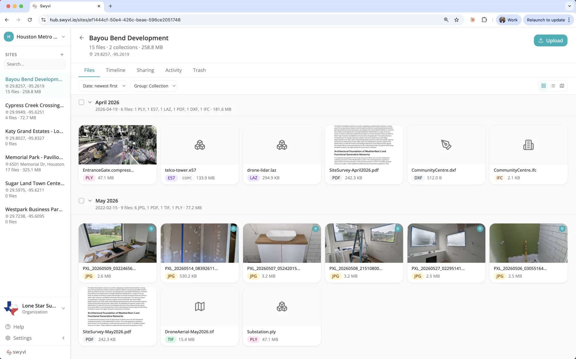
The system of record for physical environments
Send a point cloud, scan, or survey.
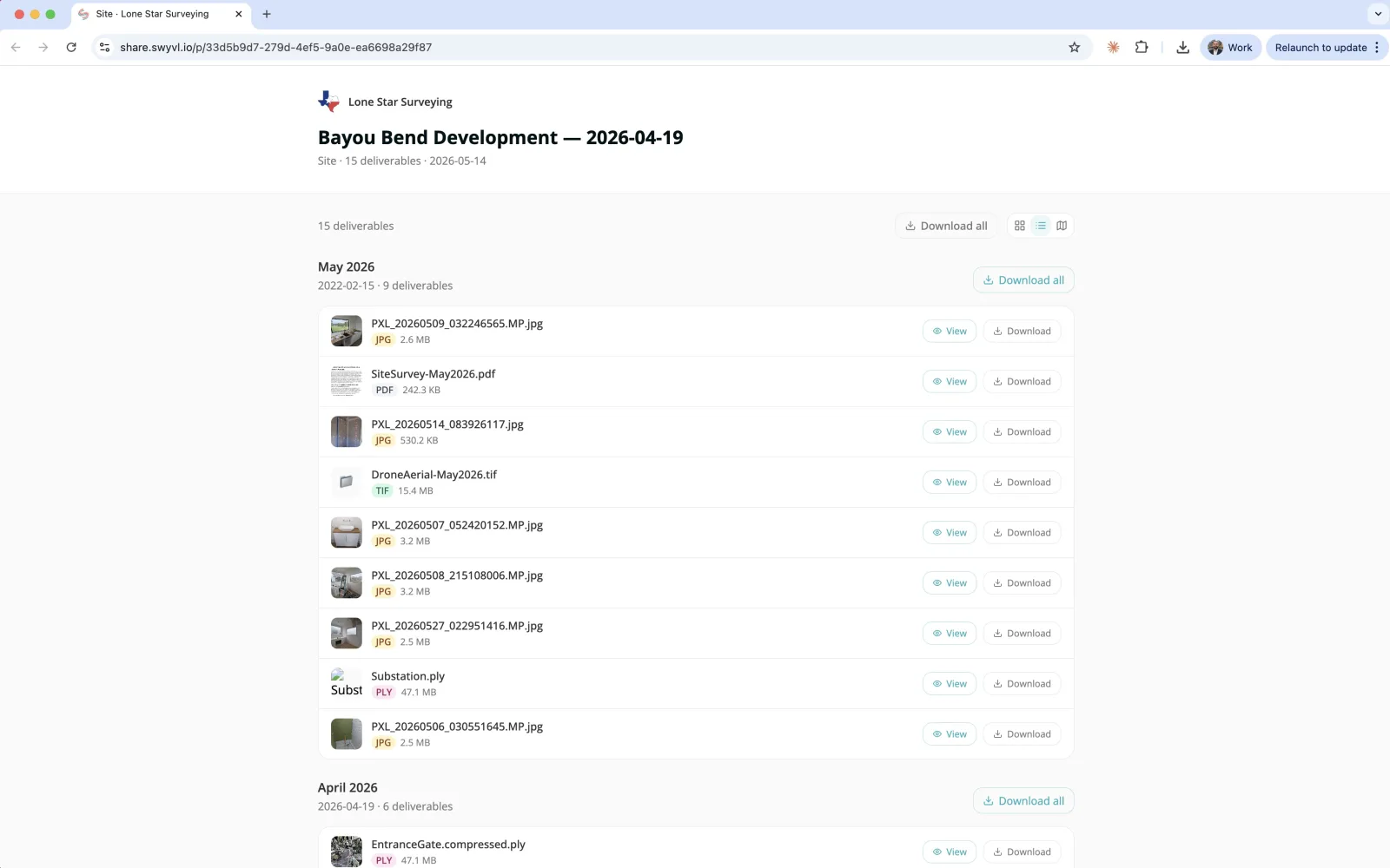
They open it in the browser.
Every scan, splat, photo, survey, document, and field observation — anchored to the physical site, time-indexed, and delivered via a branded link that clients, colleagues, and contractors can open in any browser. No software required.
No credit card required · Upgrade anytime

Capture. Organise. Deliver. Every physical site, building a record over time.
20+ file types supported natively | From capture to permanent record in under 5 minutes | 100% browser — no software
Who it's for
One platform. Every field professional.
Surveyors →
Deliver LiDAR, drone surveys, and spatial data via branded share links — not Dropbox links.
Drone Operators →
One link for orthomosaics, point clouds, video, and reports — viewed in any browser.
Construction →
Progress photos, drone orthos, and site plans as custom base maps — every update delivered to the client in a branded link.
Mining →
Site-wide surveys, stockpile scans, and compliance records — organised by site and shared with stakeholders in any browser.
Field Service & Trades →
Every job builds a site record. The next person dispatched knows the full history before they arrive.
Heritage & Cultural →
A permanent, time-indexed digital record for heritage-listed buildings, portfolios, and restoration projects.
Events & Venues →
Compliance-grade documentation of every setup — pre-event, during, post-pack-down.
Asset Owners →
All your contractor deliveries in one organised, searchable place, with full audit trail and browser-based viewing.
What happens to your site captures today — and what should.
Your client downloads gigabytes and has nothing that opens them. The capture that impressed everyone never gets seen.
Everything opens in the browser — orbit, pan, walk through. No account, no install, on any device.
Files scattered across Dropbox, WeTransfer, and shared drives.
One permanent home for every capture at every site.
They can't open the LAS, the GeoTIFF, the IFC you sent.
Point clouds, orthos, BIM, drone video — all in any browser.
Last year's visit to this site is anyone's guess.
A time-indexed record of every capture, anchored on the map.
No audit trail — a problem for regulated industries.
Full audit log — who accessed what, when, from where.
Looks like you dumped files on someone.
Looks like you built them a custom share link — and the site's record builds in the background.
Four steps. That's the whole thing.
From capture to a shared link in under 5 minutes — and your client installs nothing.
Upload anything
Point clouds, orthos, 360° photos, video, CAD, splats — straight from the browser, up to 100 GB.
Swyvl recognises it
Swyvl reads the format, extracts the metadata, and opens each file in the right interactive viewer — automatically, in seconds.
View in any browser
Every file opens in a real viewer — orbit a scan, pan an ortho, walk a 360° tour. No software, no plugins.
Share one link
Send a branded link. Clients explore everything on the site map — no account, and you see every view.
In the browser
Your site, viewable in any browser.
Every site you create in Swyvl becomes a browser-native record — drone video, point clouds, photos, plans, all anchored to the location and organised over time. No software install. No plugins.
Sites on a map
Every project pinned by location. Click into a site for an interactive map with toggleable layers, GPX tracks, and your own custom base maps.
Timeline of captures
Every drone flight, LiDAR scan, photo session, and inspection — organised by date for the site.
14 in-browser viewers
Point clouds, orthos, 360°, drone video with GPS, BIM, CAD, splats — opened in any browser, no install.
Branded share links
Invite clients, contractors, colleagues. They open one link — see the site, view every file, no account needed.
Works with every file type you capture.
No conversion. No preprocessing. Drag in your files from any capture or processing tool — Swyvl picks the right viewer automatically.
Don't see your file type or viewer? We're always adding new formats. Let us know what you need and we'll add it.
Works with the file formats every major capture and processing tool exports — LAS, LAZ, E57, GeoTIFF, OBJ, GLB, IFC, DXF, and more. No plugins, no integrations.
Everything you need to build a record of every site.
Built to make every site easier to store, share, and revisit.
Your files organise themselves.
Drop in any file — Swyvl identifies it, classifies it, and picks the right viewer. LAS goes to the point cloud viewer, GeoTIFF to the map, video to the player. No manual setup.
Files automatically group by site and capture date. Every site builds a complete, organised record — not a dump of files in a folder.
They open a link. That's it.
Point clouds, drone video, orthos, 3D models — all rendered natively in the browser. No CloudCompare, no Recap, no downloads. Works on any device.
Your logo, your colours, your domain. Every link looks like you built a bespoke share link — not like you dumped files in a folder.
And every link is part of a record that keeps growing. Every new capture you upload extends the site's history.
View tracking & notifications
Get notified the moment a share link is opened. See which files were viewed, when they came back, and whether they approved or requested changes.
Compliance-grade site record
A time-indexed audit trail for every site — every capture, every access event, every change. Essential for regulated industries: mining, infrastructure, government contracts.
Data residency you control
8 storage regions across Australia, US, UK, Europe, Canada, Japan, and Singapore. Your data never leaves your selected region.

Alex Tolson
Co-Founder, Swyvl
I've spent years in the field — in underground mines, on the Great Barrier Reef, in hot air balloons over outback Australia — capturing the world in 3D. The technology to capture data got incredible. How we delivered it to clients never changed. Swyvl is us fixing that.
Before co-founding Swyvl, Alex co-founded Lateral Vision — a 3D visualization and virtual tour company that contracted to Google Street View, delivered projects for major global mining companies, and spent nearly a decade proving that spatial data can be experienced, not just stored.
Read the full storyFree to start. Built to grow.
No credit card required. Upgrade when you're ready.
Free
No credit card
Get started in seconds
Get started free1 seat · 3 sites · 5 GB
5 share links
Solo
Independent professionals
Billed monthly
Get started free1 seat · Unlimited sites · 100 GB
Logo & colours
Team
Field teams
5 seats included
Get started free5 seats (+$15/seat) · 500 GB
Logo & colours
Enterprise
Large organisations
Tailored to your needs
Unlimited everything
White-label · SSO/SAML
API + MCP access
All prices in USD. Storage overage: $0.05/GB/mo on paid plans.
Save 15% with annual billing.
See full pricing and feature comparison →Start building the record of your sites.
No credit card required. Upgrade when you're ready.
For asset owners
Receiving spatial data from multiple contractors? Swyvl lets you track and manage deliveries from every contractor in one place — with full audit trails and browser-based viewing.
Learn more