Free tool · No signup
Free GeoPDF viewer
A GeoPDF is a PDF whose map frame carries real-world coordinates. This free viewer opens one in your browser, shows where each page sits on a map, reads latitude, longitude and grid coordinates under your cursor, and measures at the drawing's own scale. No ArcGIS, no plug-in, nothing uploaded.
Updated · Nothing is uploaded
Drop a GeoPDF or any PDF drawing
or click to browse · .pdf · plans, drawing sets and GeoPDF maps
Your file is opened in your browser. It never leaves your computer.
Scale
Check it against a dimension on the drawing. A PDF exported with "fit to page" isn't at the scale printed on it.
Keep this drawing and share it with a link
Store your files by site in Swyvl and send clients a link they open in any browser. Free account, 5 GB, no credit card.
This viewer stays free. Nothing you opened here was uploaded.
Share this drawing with a link
This free viewer only runs on your computer. Create a free Swyvl account, upload the file to a site, and send your client a link they open with nothing to install.
What is a GeoPDF?
A GeoPDF looks and prints like any other PDF. Hidden in each page are the coordinates of the map frame's corners and the coordinate system the map was drawn in. Software that reads them can place the page on a map, show coordinates under the cursor and work out the scale. Most PDF readers ignore them, which is why a georeferenced plan so often arrives "not referenced". More on how GeoPDFs work.
How do you check if a PDF is georeferenced?
- 1
Open the PDF here
Drop the file on the viewer above, or try the sample GeoPDF. Nothing is uploaded.
- 2
Look at the page list
Pages with map coordinates are marked "map", and the viewer opens the first one. A small map shows where the page sits.
- 3
Check the coordinate system
The map panel names the coordinate system, such as GDA2020 MGA zone 56 or a State Plane zone. Move the cursor to a known point and compare its coordinates.
- 4
Check the scale
The scale comes from the coordinates. Measure a dimension printed on the drawing; if it matches, the georeferencing is sound.
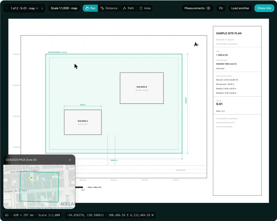
What you see
Is it georeferenced?
Pages with coordinates are marked in the page list, with the coordinate system named on the map panel.
Where it is
Each map frame drawn on a street or satellite map, with a dot that follows your cursor.
Coordinates under the cursor
Latitude and longitude, and the easting and northing in the drawing's own grid.
Scale from the coordinates
The page scale is set for you, so measurements are real straight away.
Measure and export
Distance, path and area with perimeter, metric or imperial, then export a CSV.
Drawing sets and big sheets
Move between pages; zoom into large sheets and the part in view is redrawn sharp.
How accurate are the coordinates?
As accurate as the georeferencing in the file. The viewer fits the page to the corner coordinates stored in the PDF, the same way GDAL does. In our tests:
- On a GeoPDF exported by GDAL (GDA2020 MGA zone 56), the corner coordinates the viewer reports match GDAL's to the millimeter, and a 404 m map frame measured 403.39 m by mouse.
- On the sample GeoPDF, the scale reads exactly 1:1000 and the corners land on the coordinates drawn in its grid.
Things to watch:
- Outside the map frame (title block, legend), there are no coordinates and nothing is at map scale.
- A re-saved or "printed to PDF" copy can lose its coordinates. If a GeoPDF suddenly shows none, try the original export.
- Datum. Latitude and longitude are the values stored in the file, on its own datum. GDA2020 and NAD83(2011) sit within a meter or two of the WGS 84 that web maps use; older datums such as AGD66 or NAD27 can be off by a hundred meters or more.
How does it compare with Acrobat, Bluebeam and Avenza?
Desktop PDF software measures well but needs a license and an install, and most free readers don't read map coordinates. This tool covers the common jobs, setting a scale, measuring and reading a GeoPDF, in a browser tab. To keep drawings, measure them again later and send them to clients, a free Swyvl account does that in the browser too. For full takeoffs and markup reports, the desktop tools do more.
| Tool | Runs on | Cost to measure | Setting the scale | GeoPDF coordinates | Export |
|---|---|---|---|---|---|
| This free tool | Any modern browser | Free, no account, nothing uploaded | Printed ratio, a known length, or from GeoPDF coordinates | Latitude/longitude and grid coordinates, page shown on a map | CSV |
| Swyvl account See plans → | Any browser; files kept by site, with your scans, orthomosaics and 360° photos | Free plan measures (5 GB, 3 sites, 5 share links). Solo US$49 a month adds storage, sites, branding, PDF fill & sign | Printed ratio, a known length, or from GeoPDF coordinates, saved with the file | Georeferenced pages detected on upload and measured at their own scale | Share link your client opens in a browser; notes to PDF |
| Adobe Acrobat Standard / Pro | Windows and Mac desktop | US$14.99 / $19.99 a month (annual plan) | Change the scale ratio | Cursor coordinates and measuring on geospatial PDFs | CSV |
| Adobe Acrobat Reader | Desktop | Free, but measuring only if the PDF’s creator enabled it | As Acrobat, when enabled | Not documented for Reader | Not documented for Reader |
| Bluebeam Revu 21 | Windows desktop, plus web and mobile apps | From US$260 per user a year; read-only without a subscription | Typed scale or two-point calibration | Not documented | CSV markup summary |
| Avenza Maps | iOS and Android | Free plan can’t import your own maps; Plus US$34.99 a year for 20 | Georeferenced maps only | Yes, in the app | KML, GPX, CSV |
| GeoPDF Toolbar (TerraGo) | Windows, as an Adobe Reader/Acrobat plug-in | Free | Georeferenced PDFs only | Up to three coordinate systems at once | GeoMarks, including GeoPackage |
| i2PDF Measure PDF | Browser | No account or upload | Typed as a pair, such as 1 in = 10 ft | Not described | Measurements saved as PDF markups |
Comparison as of November 2026, from each vendor's own website. Prices in US dollars. "Not documented" means the vendor's pages don't say. Check current details with the vendor. Sources: Adobe Acrobat measuring · Adobe geospatial PDFs · Adobe pricing · Bluebeam pricing · Bluebeam scale · Bluebeam without a subscription · Avenza plans · Avenza map imports · GeoPDF Toolbar · i2PDF
Frequently asked questions
What is a GeoPDF?
A PDF that knows where it is. Alongside the drawing, each map frame on a page carries the latitude and longitude of its corners and the coordinate system it was drawn in. Software that reads them can place the page on a map, show coordinates under the cursor and work out the scale. "GeoPDF" started as a TerraGo trademark; the same idea is also called a geospatial or georeferenced PDF.
How do I open a GeoPDF without ArcGIS?
Drop it on this viewer. It runs in any modern browser with no install, no plug-in and no account, shows where each page sits on a map, reads coordinates under the cursor and measures at the drawing's scale. QGIS (free desktop GIS) also opens GeoPDFs as map layers.
Is my GeoPDF uploaded to a server?
No. The PDF is opened by your browser and its coordinates are read on your computer. Only the background map tiles for the small location map are loaded from the internet, and those requests contain no part of your file.
Which GeoPDFs does it read?
Geospatial PDFs in the ISO 32000 encoding (Adobe's geospatial extension, now part of PDF 2.0), which is what GDAL and QGIS write by default, including pages with several map frames. The older OGC "best practice" encoding used by some TerraGo files isn't read yet; those open as ordinary PDFs you can still scale and measure by hand.
Which coordinate systems are supported?
Latitude and longitude always work. Coordinates in the drawing's own grid (for example GDA2020 MGA zone 56, a UTM zone, a State Plane zone or British National Grid) are shown when the PDF includes the system's definition, which most do, or when its EPSG code is in the tool's built-in table. Grids in feet show in feet.
Can I measure on a GeoPDF?
Yes. The page's scale is set from its coordinates automatically, so Distance, Path and Area give real lengths and areas straight away, and Export CSV saves them. You can still set your own scale for the page if you prefer.
Deliver GeoPDFs with the rest of the site
Upload a GeoPDF to a site in Swyvl, next to your orthomosaics, scans and 360° photos. Its georeferenced pages are detected and measure at their own scale, with notes on the pages. Your client opens all of it from one link, with nothing to install.
Other free tools
Point cloud viewer
View LAS, LAZ, and PLY files in your browser. No signup.
Open →Gaussian splat viewer
View .ply, .splat, and .ksplat scenes in your browser. No signup.
Open →GeoTIFF viewer
View GeoTIFFs and orthomosaics on a map. No signup.
Open →IFC viewer
View BIM models in your browser. No Revit required. No signup.
Open →DXF viewer
View CAD drawings in your browser. No AutoCAD required. No signup.
Open →DJI SRT viewer
Map a DJI drone video’s flight path from its SRT GPS. No signup.
Open →PDF measure
Set a drawing’s scale, then measure distances and areas. CSV export. No signup.
Open →Store and share your files with Swyvl
Upload your drawings, scans and orthomosaics by site. The Free plan is enough to get started.