Free tool · No signup
Measure a PDF drawing to scale
To measure a PDF drawing to scale, open it, set the scale from the ratio printed on the drawing (such as 1:500) or from a dimension you know, then click points to measure distances, paths and areas. This free tool does all of it in your browser and exports the results to CSV.
Updated · Nothing is uploaded
Drop a PDF drawing to measure
or click to browse · .pdf · plans, drawing sets and GeoPDF maps
Your file is opened in your browser. It never leaves your computer.
Scale
Check it against a dimension on the drawing. A PDF exported with "fit to page" isn't at the scale printed on it.
Keep this drawing and share it with a link
Store your files by site in Swyvl and send clients a link they open in any browser. Free account, 5 GB, no credit card.
This viewer stays free. Nothing you opened here was uploaded.
Share this drawing with a link
This free viewer only runs on your computer. Create a free Swyvl account, upload the file to a site, and send your client a link they open with nothing to install.
How do you measure a PDF to scale?
- 1
Open the PDF
Drop the drawing on the tool above, or try the sample drawing. Your browser opens it; nothing is uploaded.
- 2
Set the scale
Click Set scale and type the scale printed on the drawing, such as 1:500 or 1/4" = 1'-0". If the PDF may have been resized, click Measure a known length instead, click both ends of a dimension, and type its real length. A GeoPDF sets its own scale.
- 3
Measure
Pick Distance, Path or Area and click points on the drawing. Click the last point again, or press Enter, to finish a path or area. Hold Shift to snap to 15°.
- 4
Check and export
Compare one measurement with a dimension printed on the drawing, then click Export CSV for a spreadsheet of every measurement.
How do you set the scale of a PDF?
A PDF measures in points on paper, not meters on the ground, so a page needs a scale before a measurement means anything. Click Set scale in the toolbar and use whichever of these you trust most.
1. Type the printed ratio
Most drawings carry their scale in the title block: 1:100, 1:500, 1:2000. Type it as written; imperial scales such as 1" = 20' or 1/4" = 1'-0" work too. The tool works out real lengths from the page's true paper size, which it reads from the PDF and shows in the status bar (for example "A1 · 841 × 594 mm"). This is right when the PDF was exported at full size.
2. Measure a known length
If the PDF was exported "fit to page", or you aren't sure, the printed ratio will be wrong. Click Measure a known length, click both ends of a dimension line or the scale bar, and type its real length in meters, millimeters, feet or inches. The scale is then exact for that page however it was resized.
3. Let a GeoPDF set it
A GeoPDF carries map coordinates for its map frame, so the scale is already known. The tool reads them and sets the page's scale for you, labeled "from the drawing's map coordinates". The free GeoPDF viewer also shows where the page sits on a map and the coordinates under your cursor.
A drawing set is usually one scale, so a new scale covers every page unless you untick Use for every page. A scale set on one page, or a page's own map coordinates, always wins over the every-page scale.
How accurate is it?
The tool measures on the paper and multiplies by the scale, the same way a scale rule does, so the result is as good as the scale and your clicks. In our tests:
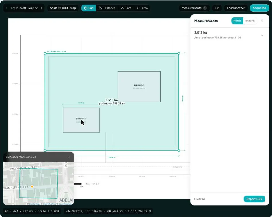
- On the sample drawing at 1:1000, outlining the 220 × 160 m site by hand reads 3.513 ha against 3.52 ha, about 0.2% under, with the page fitted to the window. Zoom in before placing points and the error shrinks.
- Setting a scale from a 100 m dimension and measuring a rectangle gave 4,635 m² against the 4,630 m² worked out from the drawing.
- On a GeoPDF exported by GDAL, the scale read from the coordinates came out at 1:5,910 and a 404 m map frame measured 403.39 m by mouse.
What goes wrong, and how to avoid it:
- "Fit to page" exports. The printed ratio is no longer true. Use a known length instead.
- Scanned drawings. A scan can be slightly stretched or skewed. Calibrate on a long dimension in the direction you are measuring.
- Mixed scales on one sheet. Details and sections are often at another scale. Set a scale for that page, or measure only within the view that matches.
- Measuring outside a GeoPDF's map frame. The title block and legend aren't at map scale.
How does it compare with Acrobat, Bluebeam and Avenza?
Desktop PDF software measures well but needs a license and an install, and most free readers don't read map coordinates. This tool covers the common jobs, setting a scale, measuring and reading a GeoPDF, in a browser tab. To keep drawings, measure them again later and send them to clients, a free Swyvl account does that in the browser too. For full takeoffs and markup reports, the desktop tools do more.
| Tool | Runs on | Cost to measure | Setting the scale | GeoPDF coordinates | Export |
|---|---|---|---|---|---|
| This free tool | Any modern browser | Free, no account, nothing uploaded | Printed ratio, a known length, or from GeoPDF coordinates | Latitude/longitude and grid coordinates, page shown on a map | CSV |
| Swyvl account See plans → | Any browser; files kept by site, with your scans, orthomosaics and 360° photos | Free plan measures (5 GB, 3 sites, 5 share links). Solo US$49 a month adds storage, sites, branding, PDF fill & sign | Printed ratio, a known length, or from GeoPDF coordinates, saved with the file | Georeferenced pages detected on upload and measured at their own scale | Share link your client opens in a browser; notes to PDF |
| Adobe Acrobat Standard / Pro | Windows and Mac desktop | US$14.99 / $19.99 a month (annual plan) | Change the scale ratio | Cursor coordinates and measuring on geospatial PDFs | CSV |
| Adobe Acrobat Reader | Desktop | Free, but measuring only if the PDF’s creator enabled it | As Acrobat, when enabled | Not documented for Reader | Not documented for Reader |
| Bluebeam Revu 21 | Windows desktop, plus web and mobile apps | From US$260 per user a year; read-only without a subscription | Typed scale or two-point calibration | Not documented | CSV markup summary |
| Avenza Maps | iOS and Android | Free plan can’t import your own maps; Plus US$34.99 a year for 20 | Georeferenced maps only | Yes, in the app | KML, GPX, CSV |
| GeoPDF Toolbar (TerraGo) | Windows, as an Adobe Reader/Acrobat plug-in | Free | Georeferenced PDFs only | Up to three coordinate systems at once | GeoMarks, including GeoPackage |
| i2PDF Measure PDF | Browser | No account or upload | Typed as a pair, such as 1 in = 10 ft | Not described | Measurements saved as PDF markups |
Comparison as of November 2026, from each vendor's own website. Prices in US dollars. "Not documented" means the vendor's pages don't say. Check current details with the vendor. Sources: Adobe Acrobat measuring · Adobe geospatial PDFs · Adobe pricing · Bluebeam pricing · Bluebeam scale · Bluebeam without a subscription · Avenza plans · Avenza map imports · GeoPDF Toolbar · i2PDF
What you can do
Distance
Click two points for a straight-line length. Hold Shift to lock the line to 15° steps.
Path
Click along a fence line, pipe run or boundary. Click the last point again, or press Enter, to finish.
Area and perimeter
Click round an outline to get its area in square meters, hectares, square feet or acres, plus the perimeter.
Export to CSV
Every measurement with its page, sheet number, type, length, area, the scale used and the points.
Drawing sets
Move between pages and sheet numbers. Each measurement remembers its page.
Big sheets stay sharp
Zoom right in on an A0 sheet: the part in view is redrawn at screen resolution.
Frequently asked questions
Is my PDF uploaded to a server?
No. The PDF is opened and drawn by your browser, and the scale, measurements and coordinates are all worked out on your computer. Nothing about the file is sent anywhere.
How do I set the scale of a PDF drawing?
Three ways. Type the scale printed on the drawing, such as 1:500 or 1/4" = 1'-0". Or click two ends of a dimension or the scale bar and type the real length between them. Or open a GeoPDF, and the scale comes from the map coordinates inside it. A scale can cover one page or every page in the set.
Why does my measurement not match the dimension on the drawing?
Usually because the PDF was exported or printed with "fit to page", so the page is not at the scale written on it. Set the scale from a known length instead of the ratio: measure a dimension you trust and type its length. That corrects for any resizing.
Can I measure a PDF without Adobe Acrobat or Bluebeam?
Yes. This tool runs in any modern browser on Windows, Mac or Linux with nothing to install and no account. It sets the scale, measures distance, path and area, and exports a CSV, which covers most quick takeoffs and checks.
Can I export the measurements?
Yes. Export CSV gives every measurement with its page, sheet number, type, length in meters, area in square meters, the scale used and the points, ready for Excel or a takeoff sheet.
Are my measurements saved?
Not in the free tool: closing the tab clears them, so export a CSV first. In a free Swyvl account the drawing keeps its scale, and you can pin notes and measurements to the page and share the drawing with a client by link.
Which PDFs work?
Any PDF your browser can open, including vector drawing sets from AutoCAD, Revit, Civil 3D or Bluebeam, scanned plans, and password-protected files (you type the password; it stays in your browser). Very large files over about 150 MB may be slow, and the limit is 500 MB.
Keep the scale, share the drawing
The free tool forgets everything when you close the tab. In Swyvl, a drawing keeps its scale, you pin notes and measurements to the page, and your client opens it from a link in any browser, next to your scans, orthomosaics and 360° photos of the same site.
Other free tools
Point cloud viewer
View LAS, LAZ, and PLY files in your browser. No signup.
Open →Gaussian splat viewer
View .ply, .splat, and .ksplat scenes in your browser. No signup.
Open →GeoTIFF viewer
View GeoTIFFs and orthomosaics on a map. No signup.
Open →IFC viewer
View BIM models in your browser. No Revit required. No signup.
Open →DXF viewer
View CAD drawings in your browser. No AutoCAD required. No signup.
Open →DJI SRT viewer
Map a DJI drone video’s flight path from its SRT GPS. No signup.
Open →GeoPDF viewer
See where a GeoPDF sits on a map and read its coordinates. No signup.
Open →Store and share your files with Swyvl
Upload your drawings, scans and orthomosaics by site. The Free plan is enough to get started.